EACH week, hundreds of planning applications come before Cornwall Council’s planning department, seeking to win approval for various plans right across the Duchy.
These plans can comprise of a number of different reasonings – ranging from permission to replace windows or listed building consent ranging up to large house building developments or changing of use of a building, for instance, from an office to a café, or flats.
Within this large and often complex system, there are a number of formats from which planning advice and approval can be sought.
These range from full applications where all the details which comprise a proposed development or work to a building are submitted, to outline applications, where further details are yet to be confirmed, for example, an outline application with reserved matters for appearance may not confirm the final proposed development but rather seek permission in principle.
An example of this is one for an outline permission for 20 dwellings on land with reserved matters for appearance and scale; the reserved matters would require further permission later for their inclusion.
Other types of applications include pre-application advice requests, where would-be developers submit often outline proposals to a local authority to ascertain whether it is likely to gain support or not prior to submitting a planning application.
The vast majority of applications are decided by planning officers employed by a local authority under ‘delegated powers’, meaning they do so on behalf of their employer, however, some applications are ‘called in’ by local councillors to be discussed at an area’s strategic planning committee meeting, meaning the final decision rests with a committee of councillors.
Construction of house near Camel Trail refused
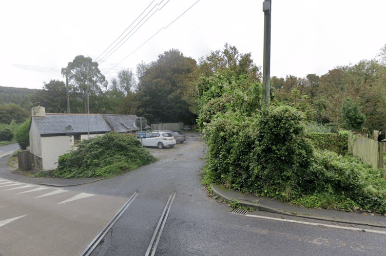
PROPOSALS for a property on land immediately adjacent to the Camel Trail at Dunmere, near Bodmin has been refused planning permission.
The application, made by Mr Murch concerned a former allotment adjoining the rear of 1 Camel Valley Cottages, Dunmere, Bodmin.
He sought to build a four-bedroom bungalow which would blend into the topography of the hill that it would sit alongside, complete with a ‘living roof’ that would be level with the main road, meaning that the property would not be overtly visible from those passing by.
In the application, he stated: “The current site is located along the A389 Bodmin to Wadebridge Road, on the Dunmere Hill. The parcel of land is sandwiched between a row of cottages called Camel Valley Cottage and the Camel Valley Cottages residents car park. The current site has been used for the last eighty years as an allotment and garden to No. 4 Camel Valley Cottage.
“The site has an existing entrance from the A389 alongside the Camel Valley Cottages resident’s car park. To the north is the Camel Valley Cottages resident’s car park and further dwellings, to the east is a stream feeding the river Camel with farmland beyond. To the south is Camel Valley Cottages and further residential properties. To the west is the Camel Trail and agricultural land.
“The building will be a flat roof four-bedroom bungalow with a living roof above. Due to the steep slope on the site the roof line will be level with the main road level. A new Cornish stone wall would separate the front garden area from the living flat roof.
“Off road parking will take full use of the existing Camel Valley Cottages residents car park. Now that No. 4 Camel Valley Cottages has their own on-site parking this frees up two spaces. There will be no parking on the proposed development site.”
Bodmin Town Council and the Environment Agency were among those who objected to the planning application.
In its response, the town council’s planning committee stated: “Bodmin Town Council do not support this application.
“There are concerns about the access and safety of residents and the general public as per the National Planning Policy Framework. It was felt that the application should be brought to the attention of the Camel Trail Partnership, if not already done so.
“It was also hoped that Cornwall Council would be particularly vigilant in its environmental and highways checks due to the site position and proximately to the river Camel and Camel Trail.”
The Environment Agency said it had serious concerns over the flood risk of the site, with no ‘acceptable flood risk assessment’ offered. It had previously stated that: “The application site lies within Flood Zone 3 defined by the Environment Agency Flood Map as having a high probability of flooding.”
Refusing the application, Cornwall Council stated several reasons, specifically: “The proposed development would represent the provision of unsustainable housing development in the open countryside, outside of any defined established settlement. Residential accommodation on this site would not achieve convenient accessibility to necessary essential services, employment opportunities and facilities, which would perpetuate an over reliance on the private vehicle and unsustainable traffic movements.
“The proposal would fail to promote an integrated approach to the delivery of new development or support a sustainable pattern of growth. In the absence of any special circumstances to justify residential development in this rural location, the proposal is not sustainable development. The adverse impacts of the proposal would significantly and demonstrably outweigh any potential benefits.
“The proposed access arrangement fails to demonstrate a safe and suitable access for the proposed dwelling and, if permitted, would be detrimental to highway safety as a result of the introduction of vehicular movements onto the A389, substandard visibility, observed traffic speeds and volume of traffic using this main road. It is considered therefore that the development is not sustainable.
“The application site is within the hydrological catchment of the River Camel which is designated as a Special Area of Conservation under the Habitat Regulations 2017. The designated site is considered to be in unfavourable condition due to high levels of phosphates.
“Insufficient details of a mitigation package has been submitted to demonstrate that this proposal would not result in an increase in phosphate levels. Given the failure of the proposal to provide any suitable mitigation, and until demonstrated otherwise, the precautionary principle must prevail in favour of nature conservation.
“The application site lies within Flood Zone 3 representing high probability of flooding as well as being adjacent to the Bodmin Town Leat which is designated as a Main River at this location. The submitted flood risk assessment makes no allowance for potential impacts of climate change and the derived flood levels for the 1% AEP and 0.1% have used only the old 2007 J-Flow levels data which is produced from a very generalized methodology and not as accurate as specific modelled data.
“The flood risk assessment fails to demonstrate that the development will not increase flood risk elsewhere, or that it will be safe for its lifetime. Furthermore, no reference is made to a sequential approach to site selection, with no evidence submitted to demonstrate a lack of any other reasonably available sites in areas at lower risk of flooding.”
- Keep up to date with the latest planning applications and other statutory notices (such as alcohol licensing and probates) that affect where you live by visiting our online Public Notice Portal – be the first to know by visiting www.publicnoticeportal.uk/cornish-times-series


-Cllr-Leigh-Frost-Jayne-Kirkham-MP-Perran-Moon-MP-Noah-Law-MP-Gus-Grand-Piers-Guy-in-a-geotherm.jpeg?width=209&height=140&crop=209:145,smart&quality=75)

Comments
This article has no comments yet. Be the first to leave a comment.