

GROUPS in Looe working to realise a major flood defence scheme are now aiming to bring the whole project forward by two years.
The Looe Flood Defence and Regeneration Scheme, at an estimated cost of between £60-million and £75-million, will not only protect hundreds of homes and businesses from the forecast impacts of continued flooding and sea level rise. It would also form part of a wider picture of projects to safeguard Looe’s place as a centre for tourism and fishing, and as a hub for the wider visitor economy in South East Cornwall.
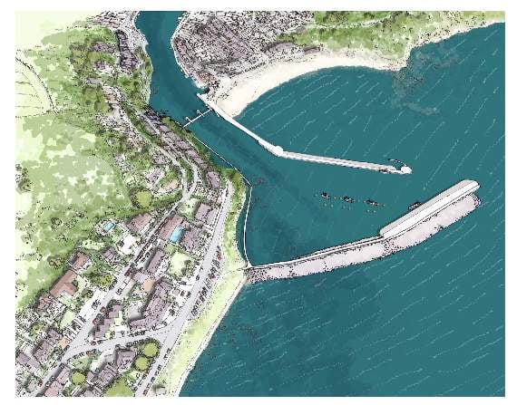
The flood defence scheme would see the construction of a tidal barrier or gate which would be closed when flooding is predicted, a southern outer breakwater, an extension to the Banjo Pier to create a low-level landing stage and access by boat at all states of the tide, a cut-off wall below East Looe’s beach to prevent tidal flooding from bypassing the barrier, and a new walkway connecting Pennyland in West Looe with Hannafore.
Looe has the unwanted title of “most flooded town in the UK” and flooding has caused £39-million in damage over the past five years. Sea level rise of more than a metre over the next century, related to climate change, will threaten many parts of the town centre as well as road and rail connections, the GP surgery, and the police station.

.jpg?width=209&height=140&crop=209:145,smart&quality=75)

Doing nothing is simply not an option, says the project board and steering group, which represents Cornwall Council, Looe Town Council, Looe Harbour Commissioners, Environment Agency, and other groups working together on the scheme. “Over time the harbour walls would fail, leading to erosion that would severely affect the town,” the board says.
“It has become increasingly clear that this vital scheme is delivered as soon as possible to protect homes, businesses and key infrastructure in Looe.”
An accelerated time frame has now been agreed as a goal, and the project board now hope to see funding secured and permissions and licences in place for construction to begin in 2024, with a projected finish date of 2026.
Cornwall Council has already committed £4.3-million to the development of a plan, and a bid for the crucial government funding required to see the defence realised will be submitted later this year.
In summer 2020, surveyors used a small amphibious vehicle to carry out a laser scan and sonar survey of the harbour, pier and seawall. Discussions have been taking place to acquire the land needed to expand the railway station and improve the service between Looe and the mainline.
Over the last four months, a very high resolution 3D survey of the entire waterfront has been conducted. This information will be used for a variety of purposes, from deciding where ground investigations need to be done, to modelling flood risk and designing proposed structures.
While face to face consultations can’t take place at the moment, a new online platform has been launched where people are encouraged to share their experiences of flooding in Looe, and their views about the proposed flood defence scheme, as well as ask any questions they might have about the project. It can be found at https://letstalk.cornwall.gov.uk/looe-flood-defence
Meanwhile, the first of a series of regular newsletters has been published containing further detailed information and images: it can be found at www.looetowncouncil.gov.uk under “news”.