
CAMPAIGNERS fighting to keep a popular Newquay headland open to the public have reached a milestone in their battle with a developer.
Glendorgal Coast Path group submitted its definitive map modification order to Cornwall Council which is the legal process used to correct errors or record "lost" public rights of way on the official definitive map and statement.
It follows the landowner Seamus Redmond from Bluechip Hotels Limited insisting in a Facebook post there is no right of way along the path and threatened to prosecute anyone who tried to use it.
Work is underway to demolish part of the Glendorgal Hotel and construct 12 luxury holiday homes including apartments, townhouses, semi-detached properties and duplex houses.
Mr Redmond has upgraded the wooden barriers to a solid steel gate complete with signs warning it is private land. He has offered locals a simple solution if they wish to keep using it: buy one of his new luxury holiday homes.
Glendorgal Coast Path Campaign gave evidence through written statements and photographs spanning from the late 1960s through to 2026 to help prove they have used for route for generations.
They believe they have a strong case to demonstrate there has been unobstructed use of the headland for more than 20 years.
The evidence gathered shows that from 112 responses 50 per cent said they used the route daily, 97.3 per cent believed the route was open to the public when they used it and 98.2 per cent stated they were never challenged, stopped or told they could not use the route.
Matt Kennedy-Smith from Glendorgal Coast Path Campaign said: “We have officially submitted our definitive map modification order application.
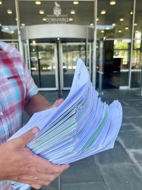
“It was a moment we’ll never forget. What started as a conversation between a few local people has grown into a community movement. Now we have handed over more than 100 public path user evidence forms, supported by pages and pages of documentary evidence.
.jpeg?width=209&height=140&crop=209:145,smart&quality=75) Controversial Athena Learning Trust set to dissolve amid community concerns
Controversial Athena Learning Trust set to dissolve amid community concerns Counter Terrorism Policing team now leading Ann Widdecombe murder investigation
  Appeal launched after motorcyclist sustains life-changing injuries in collision
 Major breakthrough as murder arrest made in Ann Widdecombe investigation
“Our submission includes historic maps, old and recent photographs, historic newspaper cuttings, vintage coastal guidebooks, Strava heat maps and even BBC Weather screenshots showing the path in use over the years.
“As we carried the boxes into County Hall, the reaction from staff said it all.
“Oh wow… that’s a lot of paperwork!”
“Our only reply was that we felt sorry for the scanning team because that was its next stop. But behind every page is something far more important than paperwork.
“Every witness statement is someone’s memory. Every photograph tells a story.
“Every map, every cutting and every piece of evidence represents generations of people who have loved and used this incredible stretch of coastline.
“Handing it over was both emotional and exciting. We weren’t just submitting documents. We were entrusting decades of memories and a shared hope that this historic route can be protected for future generations.
“The application is now in the hands of Cornwall Council.
“However, our campaign is far from over. We will continue to support the process, provide any additional evidence required, and ensure this application receives the attention it deserves.”
Comments
We've recently changed our login process. If you have an account for commenting, you will need to re-register on the login window.
This article has no comments yet. Be the first to leave a comment.