

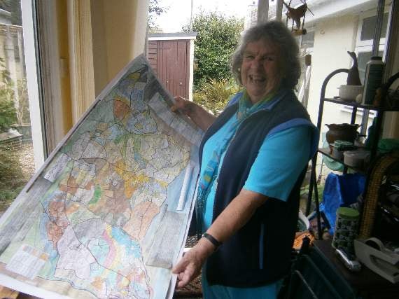
A FORMER teacher and landscape historian from Looe has produced a special historical map of the town based on the area’s old tithe map – and is using it to raise money for the local lifeboat appeal.
Jenny Wallis of St George’s Road, Looe, has been researching the origin of the field and estate names on the Looe area’s tithe map for many years, and has also found evidence for her belief that the area’s coastline once extended some miles further out into what is now Looe Bay but eroded over the centuries due to climate change and other factors.
Many of the names on the old original tithe maps – which were part of the centuries-old system by which all landowners and residents had to pay a contribution, or tithe, to the established church – were hard to read so over time Jenny has produced her colour-coded version, showing which land belonged to different estates and owners and also showing the field names clearly.
When the COVID pandemic lockdowns came she had the idea of producing a smaller pamphlet version with information on the origin of the local placenames that both visitors and residents could use.
.jpg?width=209&height=140&crop=209:145,smart&quality=75)
.jpg?width=209&height=140&crop=209:145,smart&quality=75)

The project was one of two things that kept her from feeling lonely and isolated during lockdown. The other thing was she was ‘adopted’ by a stray black and white cat who arrived at her door looking thin and gaunt.
After taking him in she named him Bubble – as he was now part of her own COVID lockdown ‘bubble’. Bubble has obviously benefited from his new place of residence as he is now looking bright-eyed and bushy-tailed.?
Jenny says her interest in the tithe map of the Looe area started at the time of the Millennium when there was a project to digitise all the maps in Cornwall.
She first became interested in maps when she was doing teacher training in around 1958. In those days you had to teach children Environmental Studies, which was all about helping youngsters to learn about and connect with the heritage and natural world of their local area.
When Jenny later decided to do special educational training she found that one way to help the pupils gain a sense of belonging was to teach them about the landscape and nature.?
She and fellow teachers would take children on field trips to locations such as Pembrokeshire in West Wales. Sometimes she would walk with pupils along the Icknield Way, an ancient trackway across eastern and southern England, and found that stories of the ancient laylines said to exist in that landscape really captured the imagination of these pupils.
All went well until there was a new headmaster who thought teaching pupils about the landscape was a waste of time. The teachers including Jenny were all aghast because they were running the field trips in their own time.
Nevertheless, Jenny continued to follow her own interest by going to classes in landscape stratigraphy, and in the relationships between fauna and flora.
Some of Jenny’s interest in nature probably came from her father, who was a gardener and? expert on flowers, and her mother, who had studied botany and geography.
Jenny was brought up at Hope Cove in Devon’s South Hams. It was from that area that her family originated and in fact she is the granddaughter of a Hope Cove fisherman and lifeboat coxswain from 1878 to 1894 James Edward Thornton, who is portrayed along with his father (and Jenny’s great-grandfather) William Thornton in a 19th century painting from the area now in the Manchester City Art Gallery.
She has written a book about the Hope Cove family and part of her inspiration for selling her map pamphlet in aid of the RNLI has come from that.
In producing her map, she also wants it to be something that has an educational value and that people can take with them on walks around the area.
The research involved has taken a lot of time though. Three historical volumes have provided useful information on origin of local place names: The Catalogue of Launceston Priory, The Parliamentary Survey of the Duchy of Cornwall in 2 vols and The Medieval Cornish Miscellany by W M M Picken.
These have helped to identify locations mentioned in the tithe records but which no-one knew where they were. Jenny also has theories on names such as Looe’s Sunrising. She says that from there no-one would be able to see the sun rising, but the bottom of the hill would be where a lot of water would come down after wet weather, so she reckons it’s a corruption of sumpth hrising, as there is a stream or watercourse in the vicinity.
It is also her belief that Looe’s Barbican may once have been the location of a so far undiscovered Roman fort due to the squarish layout of the streets and the line of nearby roads coming down to the port.
Jenny wants her map to be affordable but also to benefit a good cause, so she has decided that her printed map will be sold in aid of the RNLI at a suggested minimum contribution of £3 per map.
The proceeds will go towards the appeal for a new D Class inshore lifeboat now that the current vessel Ollie Naismith is nearing the end of its operational life.
Places where maps can be obtained include: the RNLI shop, East Looe; The Old Hall Bookshop, Shutta Road, East Looe; Purely Cornish, 18 Fore Street, Looe; The Bookshop, 2 Barras Street, Liskeard; Tregoad Holiday Park shop; Looe Bay Holiday Park reception; Looe Camping Park; The Oaks Holiday Park; The Monkey Sanctuary shop; St Martin by Looe Parish Council; Robert Henly; Roberta Powly; Barbara Reynolds; Andrea Lankston; Simon Lawes; Nigel Cummings; and the Clerk, Charles Hyde.
Jenny says she doesn’t know what she would have done over lockdown without her map project and thanks A2Z Printers of Moorswater, Liskeard, for the printing of the pamphlet and says their graphic designer Jon Puckey did a great deal of work towards it.